
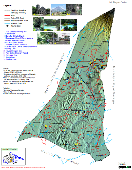
TOURISM
- TOURISM DESTINATION
SOCIO
- Household Using Shallow Wells
- Incidence of Malnutrition
- Male Population 2003
- Number of Classroom in Elem Schools
- Number of Classroom in Secondary Schools
- Number of Students in Elem Schools
- Number of Students in Secondary Schools
- Number of Teachers in Elem Schools
- Number of Teachers in Secondary Schools
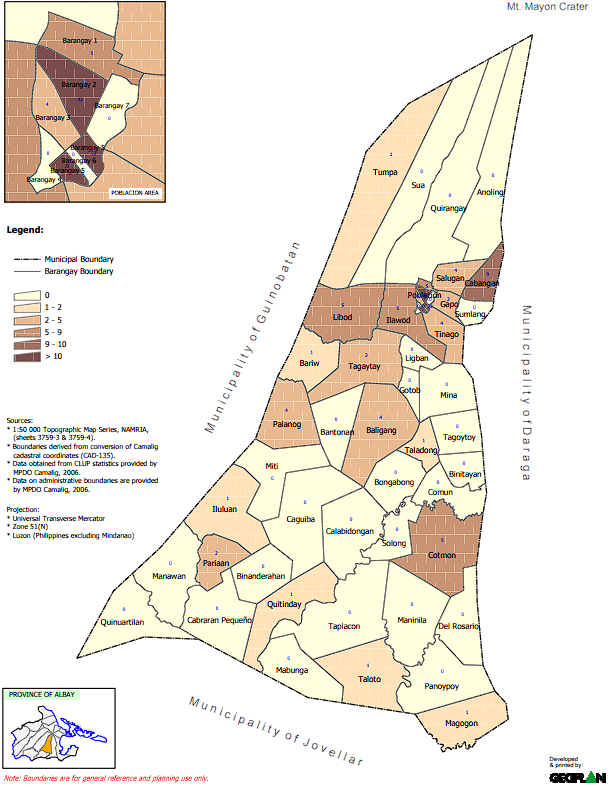
- Percentage of HH with Annual Incomes from 5000-100000
- Percentage of HH with Annual Income from 100000-150000
- Percentage of HH with Annual Income from 150000-200000
- Percentage of HH with Annual Income Greater than 200000
- Percentage of HH with Annual Income of up to 500000
- Population 2000
- Population 2003
- Population 2005
- Population 2010 projected
- Population Density 2000
- Population Density 2003
- Projected Population Density 2010
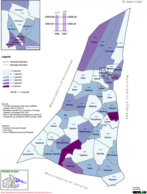
- Total Average Annual Household Income 2005
- Urban Base Map
INFRASTRACTURE
- Churches and Chapels
- Commercial Electric Connections
- Covered by Infres Projects
- Covered by Infres Projects
- Covered by Telephone Service
- Distance from Mayon Crater
- Distance to the Nearest Health Centers
- Distance to the Nearest Hospitals
- Distance to the Nearest Private Medical Clinic
- Educational Institution
- Electric Service Coverage Area
- Garbage Route Map
- Health Facilities
- Household Serve with Level 2 Water System
- Industrial Electric Connections
- Location of Brgy. Halls
- Location of Bridges
- Means and Cost of Transpo to Town Market
- Number of Deep Wells by Barangay
- Number of Improved Springs to Barangay
- Residential Electric Connections
- Road Classification
- Road Network
- Road Surface
- Status of Elementary School Facilities
- Status of Secondary School Facilities
- Urban Drainage Map
- Urban Street Map
- Utility Map
- With Elementary Schools
- With Secondary Schools
- Analytical Hills Shading
- Digital Terrain Model
- Elevation
- Hydrology
- Relief and Drainage
- Slope
- Topographic
- Watershed
2009 UPDATED MAPS *NEW
- ASHFALL HAZARD MAP2009
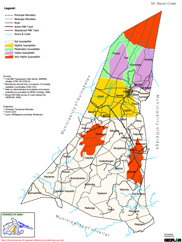
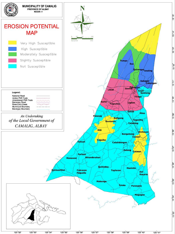
- EROSION POTENTIAL MAP2009
- FLOODING HAZARD MAP2009
- general-BASEMAP1-2009-Model
- general-BASEMAP2009-Model
- general-basemap-2-2009-Model
- general-CLIMATEMAP2009-Model
- general-COMMERCIAL FACILITIES2009-Model
- general-COMMUNICATION2009-Model
- general-CONCEPT STRUCTURE PLAN MAP 2009-Model
- general-COTMON PROPOSED URBAN MAP2009-Model
- general-DRAINAGE MAP2009-Model
- general-EDUCATION2009-Model
- general-ELEVATIONMAP2009-Model
- general-EXISTING LAND USE MAP1 2009-Model
- general-HEALTH2009-Model
- general-HOUSING FACILITY2009-Model
- general-LAND CLASSIFICATIONMAP2009-Model
- general-LAND CLASSIFICATIONMAP 2009-Model
- general-POPULATION DENSITYMAP 2009-Model
- general-POWER SUPPLY FACILITIES2009-Model
- general-PROPOSED LAND USE MAP 2009-Model
- general-PROTECTIVE SERVICES2009-Model
- general-RAINFALLMAP2009-Model
- general-SAFDZ2009-Model
- general-SAFDZ -2- 2009-Model
- general-SLOPE2009-Model
- general-SOCIAL WELFARE2009-Model
- general-SOLID WASTE MANAGEMENT2009-Model
- general-SPORTS2009-Model
- general-TOURISM2009-Model
- general-TRANSPORTATION2009-Model
- general-WATER SUPPLY FACILITIES2009-Model
- general-WATER SUPPLYFACILITIES2009-Model
- general-WIND VELOCITYMAP2009-Model
- GROUND SETTLEMENT MAP2009
- GROUND SUBSIDENCE MAP2009
- LAHAR HAZARD MAP2009
- LAVA FLOW HAZARD MAP2009
- LIQUEFACTION HAZARD MAP
- PYROCLASTIC FLOW HAZARD MAP2009
- urban-BASEMAP2009-Model
- urban-EXISTING2009-Model
- urban-PROPOSED2009-Model
- urban-PROPOSED2009NO BACKGROUND-Model